The Dome Fire – Mojave National Preserve

I watched the weather radar from home, frustrated by doctor’s appointments and other domestic obligations that would keep me away from the East Mojave during one of the first thunderstorm events of what had been so far a “non-soon” Monsoon season (storms and rain failed to materialize across most of the southwest during the summer “rainy” season). I would be there soon. It was August 15, 2020. You might think that mid-August is no time to enter the desert, especially solo, but the high elevation regions of the Mojave National Preserve (MNP) sustain mild-enough temperatures (dependent upon one’s comfort levels) through most of the summer to make life possible here. Even better, the higher elevations of MNP are dressed in beautiful juniper and Joshua Tree woodlands, offering plenty of shade, rich and diverse plant life, and abundant wildlife. 

Appointments would keep me in town through the afternoon of August 19, and I would then depart for the Preserve to hopefully meet the next arrival of monsoonal moisture. On the afternoon of August 16, my stomach sank when I learned of the fire through a Facebook group. It began following a series of dry lightning strikes at 3:51pm on August 15 and was already burning quickly through Joshua tree woodland with unstable weather and high winds exacerbating the flames. In just over 24 hours the fire had taken 20,000 acres. 

From home, sick to my stomach over the fire, I kept a close watch on incident reports and social media and quietly wept inside. Early on the 20th I received word that road closures had been lifted and I quickly departed for the Preserve. 

It was named the Dome Fire (fire map) for its origin on the geologically unique Cima Dome, a symmetrical ten mile wide granitic bulge in Earth’s crust which is revealed in nearly perfectly concentric rings on the USGS topographical map. The fire had begun on the south and west perimeter of the dome and pushed east and northeast, directly over Cima Dome and Teutonia Peak, before roaring into the Ivanpah Mountains. Aided by improved atmospheric conditions, hundreds of firefighters, and air drops of water and Phos-Chek, the fire was mostly contained and extinguished by August 19. But not before the fire had consumed more than 43,000 acres of beautiful Joshua tree desert woodlands. In less than four days nearly the entirety of the Joshua tree forest on Cima Dome had burned. 

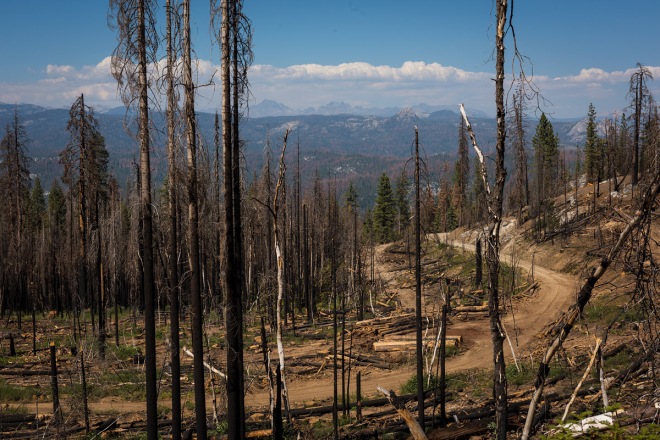
As I headed southbound on Cima Road, I could see clearly the burn scar on the dome from more than ten miles away, but it was a smoky day with poor visibility – hundreds of fires were burning throughout California and the west – and it was difficult to make out any details from this distance. Within just a few miles of the northern fire line the true scale of the fire became evident. I knew exactly how many acres had been declared burned but had not yet converted it to a relatable number: before me was 68 square miles of burned Joshua tree woodland. Not just any Joshua trees, but the largest and densest Joshua tree forest we know (they are found only in California, Nevada, Arizona, and Utah). I left the pavement at the northern fire line and in utter disbelief headed off onto a dirt road into the thick of it. I stopped and climbed atop my truck to survey the damage and what I saw appeared to be little more than a fire-blackened wasteland. All I could do was cry. 

It is important to understand why I would write this story or why I would cry over Joshua trees. This place is dear to me. I currently serve on the Board of Directors for the Mojave National Preserve Conservancy and for more than twenty years I have been exploring and adventuring in the Preserve and this was one of its most special gems. Plants, animals, and ecosystems are my interests and subjects. I can’t tell you much about contemporary culture, sports, or cinema but I can name plants by their binomial names and birds by their songs. In 2011, I was Artist in Residence at the Preserve and I concluded my residency with an exhibition at the Preserve’s Kelso Depot showing – that’s right – my Joshua tree collection. Sixteen years ago I rescued my dog, Mojave, from the Mojave desert just eighteen miles west of the summit of the Dome. We spent a lot of time here together, reveling in its extraordinary beauty, climbing the mountains that ring this beautiful valley, and studying its starry skies. She crossed the Rainbow Bridge just two and a half years ago and this fire reopened a bad wound. 

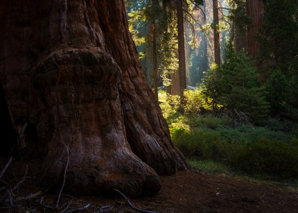
Unlike desolate alkaline basins which can feel uninviting and inhospitable, this is the most inviting portion of the desert, where Joshua trees and their shrub communities offer abundant welcoming shade and respite from a weary sun. This was the place that defied the typical expectations of the unwitting; where healthy jackrabbits,  cottontail rabbits, and antelope ground squirrels would flit between shrubs or sun themselves in the open; where choruses of coyotes would yip and howl by night; and where even a committed bird watcher would find delight in the resident Gambel’s Quail, wrens, phainopeplas, mourning doves, mockingbirds, and black-throated sparrows – a comforting place of diversity, abundance, and tranquility. 

For three days I walked through a charred landscape, revisiting familiar places and trees, only now dramatically altered by the fire – much of it a high intensity burn, with everything lying in its path completely consumed. The ground was scrubbed bare, left only with the black stains of complete combustion or white piles of ash. The wildfire had lapped at and barreled over large rock formations, reaching into crevices and caves and consuming everything: grasses, shrubs, trees, cactus, moss, lichen, even rat middens. Life seemed completely absent. These were incredibly difficult scenes to witness and process. Yet I felt I had an obligation to be here, to mourn and to grieve the tremendous loss of vegetal and animal life and an absolute transformation of a landscape I love, and to try to use my voice, my photographs, as a means to hopefully spark dialogues as to how to help better protect these trees and this landscape from the future threats they face. 

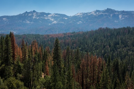
Many California ecosystems and plants are fire-adapted (or dependent) and fire can be highly beneficial to them, yet it’s deadly for non-adapted desert ecosystems like Cima Dome. Where a lightning strike might have formerly taken out one tree and its surrounding brush, the extensive destruction of the Dome Fire is the result of several factors, most significant being a changing climate. For those of us who spend a significant amount of time out of doors, drastic changes in the natural world present abundant signs of impending climate change disasters. California fires have become increasingly large and destructive and will only continue in this direction under the current climate regime – at least until humans find themselves willing to accept and tackle our most existential threat. 

I’m showing only a limited selection of photographs here. You can find here a growing gallery of my photographs from the Dome Fire aftermath; I hope you will return to the gallery for updates.

The Conservancy will be discussing with the National Park Service any possibilities for our involvement with rehabilitating the land. If you would like to be notified of ongoing efforts and potential volunteer opportunities, please consider following MNPC on its website or on Facebook

Resources

TAKE ACTION: Reduce Your Carbon Footprint (the reader may be confronted with inconvenient truths)

TAKE ACTION: Iconic Joshua Trees Need Your Help Right Now

#DomeFire feed on Twitter

INCIWEB Incident Reports and Maps

What the Fire Took Chris Clarke by Chris Clarke

L.A. Times: Mojave Desert fire in August destroyed the heart of a beloved Joshua tree forest

Dome Fire’s destruction of Joshua trees reminds us of climate change’s carnage

You are visiting the blog of landscape photographer Michael E. Gordon. For additional photos and information, please visit his website or follow him on Facebook and Instagram.

Desert Candles (Caulanthus inflatus)

Of all the arts, I believe that photography – specifically nature photography – is the one that encourages the highest levels of observation, awareness, sensitivity, and curiosity. Non-photographic artists can invent their subject matter and works. Photographers need to find theirs. We have to be intimately attuned with our surroundings and subjects and aware of the many photographic possibilities in order to make great images come to life. Such photographs never happen by accident or luck (although the latter remains a constant point of derision for our medium). Combine the love of photography with a love and awe for desert, botany, light, and life, and you’ll find someone who is willing to wait for hours to spend an entire afternoon photographing an odd patch of desert plants.

The funky-cool and not-so-common Desert Candles (Caulanthus inflatus) flickered for my attention one recent afternoon on the Mojave Desert. This California endemic – found only here – arises only after a good rainy season. And man, did we have one. In the Brassicaceae family, they may look like asparagus but are related to cruciferous vegetables such as cabbage, kale, cauliflower, and broccoli. I arrived at this incredibly unique garden under the hot light of midday but these flaming candles told me to stay until the light ran out.

There were no tulips here but still I tip-toed through the Candles and Fiddlenecks (Amsinckia tessellate). One can easily make such photographs without injuring, killing, or ripping wildflowers from their beds to impress a social media audience. It’s not really hard to do and requires no special skills or talents. You just need to care and recognize that your wants should never outweigh the needs of other living things. I treat my own garden no differently. What sort of person would destroy a wild one?

Wildflowers matter. Perhaps not to you, but they matter to every bee, moth, and butterfly that pollinates and depends upon them for their existence. Wildflowers are living things that bring life and joy to all who utilize and love them. Crushed wildflowers cannot go to seed. Less seed means a smaller seed bank. A smaller seed bank means less potential for future “super blooms”.

Should you visit any wildflower fields this spring, please be a good steward for the flowers and for our shared planet by carefully tip-toeing through them. Leave no trace. Leave it better than you found it. Give a damn. Thank you!

You are visiting the blog of landscape photographer Michael E. Gordon. For additional photos and information, please visit his website or follow him on Facebook and Instagram.

The Ten Commandments (for Outdoor Photographers)

I am part of two communities who exhibit behaviors on public lands that I am often angered by and find myself at odds with: climbers and outdoor photographers. I suspect that many have never experienced trailhead or public lands closures caused by improper/unethical/illegal use – I have.

Many climbers trample vegetation at the base of crags and boulders; they leave athletic tape, food wrappers, and the tape from rope ends wherever they fall. The rock and the climb take first priority; concern for vegetation, trampling, wildlife (including ants and all sorts of small vertebrates and invertebrates that we can’t even see), and wildlife habitat is secondary (or doesn’t matter). Sadly, this sort of behavior has now become commonplace in the outdoor photography community. In this Instagram-era, a staggering number of landscapes have now been subject to the onslaught of careless humans and an uncountable number of popular photography locations have been drastically altered by the photographers that use them. It’s wrong, disappointing, and has to end before photographers find themselves locked out of locations that they’ve commonly been able to enjoy. If you think this can’t happen, just have a chat with a member of the MTB (mountain biking) or OHV (Off-Highway Vehicle) communities for their angle.

A little more than a week ago I guided my sister, nephew, and brother-in-law through an Eastern Sierra camping/roadtrip. One of our first stops/camps was Alabama Hills below Mt. Whitney and the High Sierra crest. You Western film buffs and photographers know this place well. What you probably don’t know is that the Alabama Hills Stewardship Group has vastly improved the condition and quality of experience for visitors and photographers over the last dozen years by removing graffiti and rubbish; breaking down numerous fire rings; obliterating excess and illegal roads; and planting native vegetation to rehabilitate the abused. I’ve watched the Hills become cleaner and even more beautiful over the last twelve years. During this period digital photography has exploded – especially night sky and astrophotography – and ironically, I’ve watched its photographic ‘hot spots’ deteriorate at the very same time.

AH
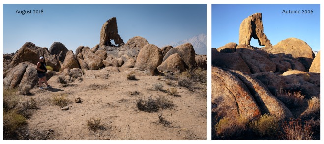
I took my sister and family to a lesser known arch in the Hills (but still popular with night photographers) and was dismayed by what we walked into: it looked obliterated by grazing cattle (there are no grazing cattle here). Although from different angles, perspectives, and focal lengths, a comparison of the two images will reveal missing, damaged, or dead plants. And I am dumbfounded by this. The other side of this arch does not look like this; it’s not the preferred angle for photographers. This is not from drought, fire, or cattle, and this is not a dense landscape – the shrubs could have been very easily avoided or worked around. Instead, the land before this arch has now become a micro-wasteland.

My sub-teenage nephew learned a few of the following commandments while we were in the field and I’m urging every photographer and non-photographer who uses public lands to please adopt and share these with other photographers, climbers, fishermen/fisherladies, etc. Humans are trashing virtually everything; lest we lose our access, please be the high-road user group that sets the examples others will desire to follow.

The Outdoor Photographers Ten Commandments

1. I don’t own this planet or this particular landscape. I’m a visitor here and my needs and wants are secondary to its primary inhabitants. I’m thankful that I get to share this space with them.

2. I will step around or over EVERY plant I encounter, no matter whether dead or alive.

3. If a plant, boulder, or other natural object is in my composition – no matter what – I will recompose instead of altering or damaging the landscape.

4. I will avoid herd mentality and behavior. I will do my very best to not travel in photographic packs, but when I do, I will be very mindful of my steps and actions as well as those of my fellow photographers.

5. I will not covet the photographs or locations of other photographers. I understand that popularity has led to the ecological decline of many ‘hot spots’ and that great photographs can be found just about anywhere.

6. If I specialize in night photography, I will make sure that I have adequate daylight preparation or proper nighttime illumination so as not trample or destroy ANY vegetation anywhere around me.

7. I will never take anything, leave anything, or alter anything in the pursuit of my photographs.

8. If I can’t make the image I desire without breaching these commandments, I will walk away empty handed.

9. I will educate my fellow photographers and students (if you teach/lead workshops) about the critical importance of field ethics.

10. In the existential scheme of things, me and my photographs don’t really matter. It’s never worth abusing plants or a landscape to make an insignificant photograph.

You are visiting the blog of landscape photographer Michael E. Gordon. For additional photos and information, please visit his website or follow him on Facebook and Instagram.

Mojave Desert Boondoggles: The Cadiz Valley Water Conservation, Recovery and Storage Project

Cadiz

“…the voice of the desert is the one which has been least often heard.
We came to it last, and when we did come,
we came principally to exploit rather than to listen.
Joseph Wood Krutch

It’s long been acknowledged that the Mojave Desert provides the most ideal location for our prisons, landfills, renewable energy plants, military installations, military bombing ranges, and royalty-free access to minerals and water. In what other ways could man possibly benefit from the realm of desert bighorn sheep, extraordinary seasonal wildflower blooms, desert tortoises, and wild desert oases? Unfortunately, this is the traditionally held [and ignorant] view of and behavior toward the the California desert and its resources.

Bonanza

THREATENED: Bonanza Spring and the Clipper Mountains

The publicly-traded company Cadiz, Inc.  grows citrus and avocados on its 45,000 acres of privately held desert land in Cadiz Valley (water intensive farming in the desert?). Cadiz has proposed to mine 50,000 acre-feet of shared groundwater every year from beneath Cadiz Valley while absurdly claiming that pumping from the basin would not affect Bonanza Spring (seen in the attached photos), or any other springs in the adjacent Mojave Trails National Monument or the Mojave National Preserve to the north. U.S. Geological Survey geologists assert that only 5,000 to 6,000 acre-feet per year of recharge is possible (this is, after all, the driest desert in North America). It’s simple math: drawdown will exceed recharge (we learned this nearly one hundred years ago with the Owens Valley/Owens River and LADWP). For nearly two decades, Cadiz, Inc. has tried to advance their water mining project and for nearly two decades they have failed. Why?

“Access to new water supplies is extremely critical to the continued vitality of our cities,” says California Senator Tony Cárdenas in a promotional document defending Cadiz. But will a private water sale to one county (its current proposal) benefiting a mere 400,000 people offer relief to a metropolitan area of 13 million? Cárdenas falls in line with those who believe that coastal cities can sustain infinite growth (“vitality”) without having an adequate local water supply. It is both illogical and irrational for a coastal city to suggest that it requires rare desert water for its “vitality”.

The California desert conservation community has been repeatedly successful at beating the nonsense served up by Cadiz; forward movement for their water mining venture has been blocked again and again. That is, until the 45th President of the United States moved into the White House. Of all places, why would POTUS have an interest in the remote California desert and in a water project that serves less than half a million souls? Why would this unremarkable water project on the remote Mojave Desert make Donald’s Top 50 Priority List of Emergency and National Security Projects? Follow the money trail!

In late July of 2017, the 45th Administration confirmed David Bernhardt, a highly controversial pick, for the Number 2 post at the Department of the Interior:

“Senator Dianne Feinstein (D-Calif.) called on David Bernhardt, President Trump’s nominee for Deputy Secretary of the Interior, to recuse himself from all matters concerning the Cadiz water extraction project. Bernhardt is currently the head of the natural resources division at Brownstein Hyatt Farber Schreck, the lobbying firm that is representing Cadiz.” “Given the fact that your current firm, Brownstein Hyatt Farber Schreck, LLP, is contracted to lobby on behalf of Cadiz, Inc., I remain deeply concerned about any potential conflict of interest should you serve as Deputy Secretary of the Department of the Interior—the agency responsible for oversight of the federal lands related to the Cadiz proposal,” Senator Feinstein wrote.”

If , as the proponents suggest, the project is good and necessary, then why has it been hotly contested and written about for so many years? Does it make any logical or ethical sense to steal water from an arid desert and its wildlife to serve a coastal city? Several hours worth of reading and viewing can be found in the numerous links provided below. Start with the fist four articles marked in bold.

Protect and preserve your Mojave Desert. Thank you for reading and opposing this dirty project.

FOR MORE INFORMATION:

The Unique Mojave Desert Oasis at the Center of the Cadiz Controversy

The Cadiz water scheme: How political juice kept a bad idea alive for years

Cadiz Inc.’s pipe dream to drain a California desert spring

The Trouble with Cadiz

The Absurdity of the Cadiz Water Export Scheme

CADIZ WATER MINING PROJECT FALTERS WITH PUBLIC SCRUTINY, ELECTION SETBACKS

Follow the Money: Cadiz Cash Funds Study in Favor of Plan to Drain Mojave

How Interior’s top lawyer is paving the way to drain California’s desert and deliver millions to Secretary Bernhardt’s former law firm

Protect CA from Trump-Supported Desert Water Mining Project

Senate should OK SB 307 to give California more review of Cadiz aquifer harvesting project

The Cadiz project to drain the desert is a bad idea

STUDY: CADIZ WATER PROJECT SCIENCE UNRELIABLE, WOULD JEOPARDIZE DESERT SPRINGS

Feinstein Slams Decision to Kill Cadiz Bill in State Senate

The Cadiz Pipeline (audio: jump to 8:05)

Loan to Jared Kushner raises questions about California water project

Study shows Cadiz water project would threaten spring in national monument

Cadiz project’s harm wouldn’t be limited to the desert

Environmental groups sue Trump administration over California desert groundwater project

A Controversial Plan to Drain Water From the Desert? Go for It, Trump Administration Says

Federal policy change criticized for giving ‘free pass’ to controversial desert water project

Forget it, Jake: It’s Cadiz

Will Cadiz Project Drain Desert Aquifers?

The ludicrous plan to pump Mojave water to L.A.

Opinion: AB 1000 Would Protect California’s Deserts From Trump

The scheme to pump desert water to L.A. could destroy the Mojave. California’s Legislature needs to block it

WATER IS PRECIOUS IN THE DESERT. SPEAK UP TO PROTECT IT.

Cadiz Water Project should be nixed

TAKE ACTION: Protect California’s Precious Desert Water Resources!

State Legislation Introduced to Protect Water Resources, National Parks and Public Lands in California Desert

Cadiz: The Desert Water Pimps

Interior head says public lands can make U.S. a ‘dominant’ oil power

Secretary Zinke’s Magic-8-Ball approach to policy making

Trump eases the way for a controversial water pumping project in a California desert

Mojave Desert Feinstein asks Trump administration to protect desert water

Cadiz Inc. would harm the Mohave. Here’s how

Cook: Orange County Water District Should Distance Itself from the Cadiz Water Project

Feinstein to Zinke: Don’t Let Cadiz Destroy Pristine Desert

Feinstein: Trump Nominee Should Recuse Himself from Cadiz Water Project

Water extraction project would be destructive to California’s Mojave Desert

Desert Water Project Would Threaten Tribes’ Sacred Lands

How you can tell Trump cares nothing about water: He’s supporting the ridiculous Cadiz project

National monument boundaries protect our heritage: Guest commentary

Protect the Groundwater Beneath Our National Treasures

Trump’s pick for a top Interior post has sued the agency on behalf of powerful California water interests

You are visiting the blog of fine art landscape photographer Michael E. Gordon. For additional photos and information, please visit his official website. You can also find Michael on Facebook.

Preserving Public Lands with Photographs

GC163The National Parks Conservation Association invited me to Washington D.C. last week to lobby on behalf of OUR public lands, our National Monuments, the Mojave Desert, and the $12 billion National Park Service maintenance backlog. Although we had an appointment with Senator Feinstein’s, staff, on Tuesday morning I had the unexpected opportunity to directly offer my thanks to California Senator Dianne Feinstein for all that she has done for conservation (especially on my Mojave Desert) in the great state of California. Senator Feinstein championed three of our newest National Monuments (Sand to Snow, Mojave Trails, and Castle Mountains) and I gifted her with a framed print of Castle Mountains National Monument. She was departing office and quickly heading towards the Capitol for a vote but very graciously spared me her time. Her face seemed to light up when I held up the piece for her. I dared not ask for a photo – I was shocked when she wanted one (with her own iPhone!). She loved the photograph and frame. She could have quickly blown me off and directed me to her staff but that did not happen. What a gracious lady and champion of our state. THANK YOU, Senator Feinstein!

Regarding the NPS Maintenance backlog (aka National Park Service Legacy Act of 2017): Please contact your Senators today and ask them to co-sponsor S.751. Next, contact your Representatives and ask them to co-sponsor H.R.2584 (the House companion bill to S.751).

Finally, if you have yet to send in your comments regarding the current Administration’s “review” of our National Monuments, please do so TODAY (deadline is July 10, 2017). Tell the Department of Interior that you do not want your Monuments altered in any fashion and that your National Monuments (in their current state) are not available for commercial energy interests (the real reason behind this “review”). Comments from others can be viewed on the right side of the page and can be helpful in drafting your own words. Many THANKS for taking action on behalf of our extraordinary public lands!

My sincere THANKS to David Lamfrom and Emily Douce of National Parks Conservation Association for making possible my lobbying day and the meeting with Senator Dianne Feinstein.

You are visiting the blog of fine art landscape photographer Michael E. Gordon. For additional photos and information, please visit his official website. You can also find Michael on Facebook.

America: Your National Monuments are Under Attack

Proposed Mojave Trails National Monument

Mojave Trails National Monument – under “Review”

This is a very long post of vital national interest so I hope that you’ll bear with me…

America, your National Monuments are under attack even though the 45th Administration mildly terms it “review”. From the New York Times, April 26, 2017:

President Trump on Wednesday ordered the Interior Department to review the size and scope of national monuments larger than 100,000 acres created since 1996. He wants recommendations on whether any of those large tracts should be scaled back by presidential authority or by Congress.

Mr. Trump, signing the order at the Interior Department, described the designations as a “massive federal land grab” and ordered the agency to review and reverse some of them.

“It’s time to end these abuses and return control to the people, the people of Utah, the people of all of the states, the people of the United States,” the president said.

Yesterday’s egregious Executive Order (“Review of Designations Under the Antiquities Act“) hits too close to home for me and impacts every American. This is not an issue of politics; it is an issue of national heritage and American pride. Far too many Americans are incognizant of what is at stake with this Order. Recognize that people from around the world visit America to experience and enjoy what is absent from much of the world: our incredible National Parks, National Monuments, and wide-open protected spaces of the American west (sorry, Eastern U.S.). This cannot be taken for granted as you are now bearing witness to the potential vulnerability of these designations under tyrannical rule. Numerous polls have demonstrated that voters agree on public lands: we want our lands protected, we desire access for recreation, and we oppose increased fossil fuel development. If you agree, now is your time to be a patriot and act for America.

Nine National Monuments in California will see “review” under this Order. I have been personally involved with the designation of four (San Gabriel Mtns NM; Sand to Snow NM; Mojave Trails NM; Castle Mountains NM) through my photography, letter writing, attendance at public meetings, and speaking at public meetings.

My first involvement was with the San Gabriel Mountains NM. The movement towards it’s formation began in 2003. I photographed the region under contract beginning in 2010 (my photography was used to aid in the passage of designation). Passage of the Monument did not occur until late 2014, and only after much public meeting, discourse, and compromise.

Patently false statements are made when the President calls our National Monuments “massive federal land grab[s]” and the Interior Secretary says that he’ll “give that power back to the states and to the people where it belongs.” We, the American people, own this land (not the “feds”); you already have the power (it’s your land); and much public process was part of their ultimate designation. This Administration continues to lie to Americans on behalf of the harmful extractive industries it is beholden to (what’s that about “draining the swamp”, you say?)

A particular segment of the Executive Order  is of great concern; I am emboldening the parts one should take careful note of:

Monument designations that result from a lack of public outreach and proper coordination with State, tribal, and local officials and other relevant stakeholders may also create barriers to achieving energy independence, restrict public access to and use of Federal lands, burden State, tribal, and local governments, and otherwise curtail economic growth.”

In reading this statement, let us not forget that we now have a Con Man real estate and golf course developer as President and an oil man as Secretary of State. The phrases “energy independence” and “economic growth” are ideas incompatible with land protection. If this Administration successfully achieves its goals of reducing the size or revoking the status of any National Monument, the door opens wide to yet more oil production and/or cattle grazing on America’s most beautiful and treasured lands. Will you allow this?

“[L]ack of public outreach and proper coordination…” can be summarily dismissed as a false statement (please see earlier links). Bears Ears NM in Utah is high on this Administration’s hit list (OIL!); note many public meetings with stakeholders took place prior to its designation as well.

[R]estrict public access to and use of Federal lands…” is another summarily false statement: NO citizen is denied access to any part of any National Monument at any time. You may not be able to ride your four-wheeler to your destination any longer, but complaining about a loss of such former use as off-roading demonstrates a misunderstanding of the reason for and need to protect public lands. If you’d like to see what is permitted versus prohibited at any particular National Monument: https://headwaterseconomics.org/wp-content/uploads/NatlMon_Permitted_Uses.pdf

The terms “Federal lands” and “public lands” are often used interchangeably. Federal lands are lands in the United States for which ownership is claimed by the U.S. federal government, pursuant to Article Four, section 3, clause 2 of the United States Constitution. Ownership of these lands is claimed by the U.S. on behalf of national and public interest (managing and distributing 327 million property deeds would prove very difficult). These are public lands to which all Americans (but not just Americans!) have 24/7/365 access. The exception to this rule are lands claimed by the Department of Defense for their training exercises (nearly 2 million acres here in California).
LINK: https://fas.org/sgp/crs/misc/R42346.pdf

Attempts to block National Monument designation and supporters of the 45th Administration’s Review of Designations Under the Antiquities Act incorrectly cite loss of “traditional” use under new National Monument designations as their source of opposition: Off-roading; hunting; grazing; loss of valid existing rights, etc. Blanket statements regarding blanket prohibitions cannot be made; some Monuments allow hunting, some allow grazing, some allow off-roading. Complaints about loss of mining activities demonstrates a misunderstanding of the reason for and need to protect public lands. Please see: https://headwaterseconomics.org/wp-content/uploads/NatlMon_Permitted_Uses.pdf

These are the basic and most important facts regarding this Order; links to additional articles and details can be found at the end of this article.

Now, will you PLEASE do this for America?
1. Please share, reshare, overshare this post or any other like it regarding this Review of Designations Under the Antiquities Act. Here is where sharing is truly caring.

2. Call Interior Secretary Ryan Zinke at 202-601-3839 and tell him that any attempts to revoke or shrink our national monuments is an assault on our historical, cultural, and natural heritage. You can also send him an easy form-fill email:
https://secure.npca.org/…/Advocacy;jsessionid=00000000.app3…

3. Contact your Congressperson and tell him/her that any attempts to revoke or shrink our national monuments is an assault on our historical, cultural, and natural heritage. His/her job depends upon their fight for your public lands; fire them (with your next vote) if they fail to act. http://www.house.gov/representatives/find/

4. If you operate a business or reside in San Bernardino County, California (home to Sand to Snow NM; Mojave Trails NM; Castle Mountains NM), please contact Representative Paul Cook at (760) 247-1815 and tell him that any attempts to revoke or shrink our National Monuments is an assault on our historical, cultural, and natural heritage. You can also email him: http://cookforms.house.gov/contact/
Specifically request that Rep. Cook send a written letter to the Department of Interior defending the designations and existing size of Sand to Snow NM, Mojave Trails NM, and Castle Mountains NM (all are in his District). His job depends upon his ability to fight for your public lands; fire him (with your next vote) if he fails to act. NOTE: office staff may seem uninterested in your call and may dispense false information by stating that Representative Cook cannot do anything. You may be told to call the President with your concerns. Persist, RESIST.

THANK YOU for what you do for America!

You are visiting the blog of fine art landscape photographer Michael E. Gordon. For additional photos and information, please visit his official website. You can also find Michael

Bearing Witness

This essay features numerous links to important illustrations and articles referenced – please click them.

_DSC4889

Michael worships a Giant. Sequoiadendron giganteum, Sierra National Forest

For many years in the West we’ve been hearing and learning about drought-stressed trees (USDA Drought Monitor), bark beetles, and climate change. My anger is justified when the 2016 GOP Presidential nominee comes to California for money and support and declares that our drought is political, not real.

During my adult life, “permanent” snowfields in the High Sierra have disappeared; its glaciers are dying; and alpine ice climbs I once made can no longer be repeated (not until the next ice age, anyway). I’ve also experienced the disappearing glaciers of Glacier National Park (expected to be gone by 2030) and near and dear to me, Joshua Tree National Park could lose its namesake trees by the end of this century. Overt signs of climate change are available everywhere in the West – if one is paying attention and not politically motivated to deny them.

_DSC4965

Giant Sequoia, Sequoia National Park

Following the opening reception of my latest exhibition in Sacramento, California, I decided to take the longer and slower route back to Southern California through the western side of the mighty Sierra Nevada mountain range. As a lifelong hiker, climber, and lover of the Sierra, I have always enjoyed its tremendous diversity. The east side of the range rises abruptly more than ten thousand vertical feet over the Owens Valley – from high desert to the alpine zone and the granitic massif of Mt. Whitney in just a few short horizontal miles. By comparison, the west side of the Sierra makes a long and gradual rise from the San Joaquin Valley towards its mighty crest – nearing sixty miles at its widest – containing chaparral and oak covered foothills, shadowed and fern-filled forests containing massive conifers (including the world-famous Giant Sequoia/Sequoiadendron giganteum), and life-giving rivers (the Kern, Kaweah, Kings, Merced, Owens, and many others) that make habitation and agriculture possible in otherwise arid California. While the East side is the dry side of the range, the west side is typically forested, wet, and green – lush and verdant by California standards (Pacific Northwesterners are laughing). My recent tour of the range, however, has forever altered my view. The Sierra Nevada will never again in my lifetime look the way I once knew it.

_DSC4938

Transformation – Sierra National Forest

On August 11th – the day before I began my drive to Sacramento – I received from a friend a link to a disturbing article: “Forests of fatalities: after 70 million tree deaths, worst “still to come – which highlights tremendous tree mortality throughout the state. A Washington Post article of December 2015 similarly suggests “fairly consistent predictions of widespread loss of piñon pine and juniper in the southwest, sometime around 2050.”As I headed north on Interstate 5 through the San Joaquin Valley- the Valley that feeds much of America’s humans (not its livestock) – I was shocked to see so many dead crops, dying trees, and fallow fields. Some of these “Central Valley” communities have gone dry in recent years and have had to truck in water just for human consumption.

Outside of Yosemite Valley, my busy schedule over the last couple years had kept me away from most of the western Sierra. My return was met with much shock and sadness. The U.S. Forest Service has declared that Sierra tree mortality jumped eight-fold from 2014 to 2015 – from 3.3 million dead trees to 29 million dead trees. In 2014, I might have suggested that there were no dead trees in the Western Sierra. No matter where one looks now, a sea of dead trees encompasses the view.

_DSC4939

Thousands of dead conifers through a haze of wildfire smoke. Chiquito Ridge, south of Yosemite National Park

As I made my way from Sonora to northern Yosemite National Park, I traversed some new ground and received yet another horrifying glimpse of Rim Fire aftermath. I was in Yosemite NP while the Rim Fire burned and distinctly recall near zero visibility at times. That fire had begun and consumed approximately 400 square miles of Stanislaus National Forest and Yosemite NP just three years prior. The view from a prominent overlook revealed not a verdant green forest filled with undergrowth, deer, and birds; rather a brushy and barren landscape that will likely never return to its former verdant glory (not in our lives).

_DSC4945

Can’t see the forest for the dead trees. 2015 Willow Fire aftermath – a long view to Mounts Ritter and Banner in the Eastern Sierra

Making my way further south only revealed more horror. For the first time I got a glimpse of the 2015 Rough Fire aftermath which ravaged Sierra and Sequoia National Forests and parts of Kings Canyon NP. A prominent overlook of Kings Canyon revealed a nearly desertified landscape, looking more akin to dry southern California ranges than the Sierra I once knew. I found myself becoming more depressed about the bleak devastation before me and believed that climbing a mountain might deliver good tidings – I headed further south to Mineral King Valley (Sequoia/Kings Canyon NP).

_DSC5145

Beautiful Mineral King Valley filtered through the smoke of the Sequoia NF Cedar Fire (still active at time of this writing)

IMG_4835

Sawtooth Peak (the prominent fin on right), Needham Mountain (behind), and Columbine Lake. Mt. Whitney is visible far to the east.

I aimed for Sawtooth Peak, six miles and 4500′ elevation gain from my camp in Mineral King Valley. I started walking early to beat the heat and meet my wild neighbors who keep different schedules. Along the way I met at close range numerous marmots, grouse, squirrels and velvet-antlered mule deer. Walking alone and quietly always brings rewards. As I neared Sawtooth Pass, I began to see smoke moving my way from the south.

Hiding out under the trees of the Sierra for several days prior, I was unaware that yet another fire had erupted while I journeyed south. Daily sky views to that point had never been promising. Always orange or gray – never blue – the central California sky had been altered for weeks by the Soberanes Fire on the coast (erupted on July 22, still active at time of this writing).

_DSC5101

Mineral King Sierra with a plume from the Cedar Fire blowing up to the south

As I neared the summit I saw a huge plume to the south. My heart sunk; not another one!? At first I believed that it might be the Blue Cut Fire on the San Bernardino National Forest far to the south – it had only begun a few days prior. Little did I know that the Lake Isabella region was getting hit by yet another new and quickly-growing fire (which had suffered the devastating Erskine Fire only weeks prior).

Climb the mountains and get their good tidings. Nature’s peace will flow into you as sunshine flows into trees. The winds will blow their own freshness into you, and the storms their energy, while cares will drop off like autumn leaves. John Muir

IMG_4837

I look distressed. Self-portrait on the summit, with the rugged Kaweah Peaks behind me

Quiet walks in the wild and climbing mountains has always been my antidote. It uplifts, it nurtures, it restores, it heals. But good tidings diminish quickly when even the view from a summit leaves one with a feeling of anguish. I stayed as long as I could. The air was getting thicker with smoke, my breathing was altered (especially at more than 12,000 feet above sea level) – I decided to depart before the smoke or my disposition worsened.


_DSC5117

My last look south from the summit

California’s natural landscape is very dynamic and has always been shaped by wildfire – this is not likely news to anyone. But it all changes when one factors unstoppable population growth, historic drought, community building in hazardous zones, and ultimately – repeated human-caused fires (not wild: power tools, downed power lines, bullets, sparks). We are helping to quickly transform and destroy the landscape we love.

Among the books in my collection is Charles Little’s The Dying of the Trees. Written in 1995, Little offers insights to dying forests around our globe. Much of it human caused, but not much mention of climate change. It was at that point beyond our knowledge and not part of our everyday lexicon. Only twenty-one years later, climate change has become very real very fast, and very threatening to our own ways of life. Every western U.S. state is suffering deeply from its effects; models predict it will only worsen.

The Sierra Nevada I once knew is no longer. Attributing blame is unimportant; acknowledging it and acting on it is paramount. Should any reader of this essay be among those who deny the overwhelming science and evidence of climate change , I invite you to California for a very personal and sobering tour.

You are visiting the blog of fine art landscape photographer Michael E. Gordon. For information and photographs, please visit his official website. You can also find Michael on Facebook.


Soda Mountains: VICTORY FOR THE MOJAVE DESERT! San Bernardino County Supervisors REJECT Soda Mountain Solar

_MG_8541-8550

Updated 24 August 2016: VICTORY FOR THE MOJAVE DESERT! San Bernardino County Supervisors REJECT Soda Mountain Solar!

THANKS to all who pushed so hard to get San Bernardino County to deny the harmful Soda Mountain Solar project. This project has been hotly contested since 2009; first being fast-tracked, then de-prioritized, then sold, then bought by Bechtel, then back in the fast lane, then hamstrung by the City of Los Angeles’s decision not to buy the power, then approved by the Interior Department, then sold to Regenerate, and yesterday (Aug 23, 2016) denied by the San Bernardino County board of Supervisors. Hands in the air!

Tens of thousands of Americans opposed this project, as did scientists, the National Park Service, and damn near the entire California desert. This was a remarkable doing and could not have happened without the concerted effort of thousands of community voices and leaders. The National Park Service and the California Department of Fish and Wildlife stood up against this bad project. So many organizations said no. Pushing back on this bad project draws a line in the sand that bad projects don’t get a free pass to harm our parks, our wildlife, or our communities.

SB-SupPlease thank San Bernardino County Supervisors Lovingood (email), Gonzales (email), and Rutherford (email) for their powerful votes. As our walk was not easy, neither was theirs – the Unions pushed really hard. The incredible organizing done by Sierra Club and the Alliance for Desert Preservation, in addition to so many groups and activists, made a huge difference. Thank you!

Many people thought this couldn’t be accomplished. A special place lives to fight another day. A wise decision and a good day for Mojave National Preserve, for our communities, and our desert. Forget Texas – don’t mess with the California desert!

Previously published:

On February 12, 2016 the Obama Administration demonstrated great leadership and foresight with its designation of three new National Monuments in the California desert (Sand to Snow, Mojave Trails, Castle Peaks). A mere eight weeks later, on April 5, 2016 – this same Administration lost its mind and approved a hotly-contested solar project on previously undeveloped California desert wildlands.

The Soda Mountain Solar Project has been contested from the get-go: By scientists, biologists, current and former National Park Superintendents, public stakeholders, and numerous other organizations and individuals who provided a plethora of logical and scientific reasons (via written comment submissions and during public meetings) why this project should not move forward at this location. First and foremost: the proposed project boundary is a mere 1/3 mile from the boundary of the Mojave National Preserve. Allow me to say it again just in case you didn’t catch it: Our federal government approved an industrial project a mere one-third of a mile from one of our third-largest National Park unit. Among numerous other significant impacts, this project would severely threaten the lives and migration patterns of bighorn sheep who reside and move through the Soda Mountains.

Please have a look at the photo heading this post. Proponents of this project claim that they have mitigated visual impacts of the project from within the Mojave National Preserve by removing from development lands north of Interstate 15. My photograph illustrates either the Bureau of Land Management‘s (BLM) disingenuousness or that it knows much less about the land we have entrusted it to manage than does this landscape photographer. That’s a two way view: the Kelso Dunes, Providence Mountains, and Granite Mountains of the Mojave National Preserve can all be seen in the background. If one places themselves in these locations inside the Preserve post-development, solar panels will fill in the background. Are these the views we want and expect from inside a unit of our National Park system?

During public and private meetings over the last few years, Bechtel was urged to take this project elsewhere where it could not destroy previously undeveloped desert and seriously threaten wildlife. Guess which finger they held up in reply?

During public and private meetings over the last few years, the BLM and Department of Interior were asked to not permit this project to move forward where it would destroy previously undeveloped desert and seriously threaten wildlife – there are better and more sensible options. Guess which finger they held up in reply?

This solar proposal has no power purchase agreement and the City of Los Angeles has stated that they will not purchase power from this project due to its environmental impacts.As Chris Clarke points out in this KCET article, the Los Angeles Department of Water and Power and San Bernardino County are doing a better job at protecting the California desert than the Bureau of Land Management (an agency entrusted by the public to protect our public lands in the public interest. Note public interest, not corporate).

The Center for Biological Diversity  suggests that “a recent report identifies nearly 1.5 million rooftops throughout Los Angeles County that could be used as solar power generators that would create 19,000 megawatts from rooftop solar. The total rooftop solar potential for the city of Los Angeles is more than 5,500 megawatts (more than 15 times what the Soda Mountain solar project would generate), which could power the city on most days since the highest-ever peak in Los Angeles was 6,177 megawatts.”

Dear President Obama: Why would you protect but then sign-off on the destruction of my beautiful Mojave Desert in the span of only eight weeks? Visitors come from around the world to tour and enjoy these vast and unspoiled landscapes.

Given that this project ignores and defies directives set forth in the Desert Renewable Energy Conservation Plan (six years in planning) and given the massive science against and opposition to this project, I am left wondering who took the bribe? 

WHAT CAN YOU DO?

Read more on the following pages:

You are visiting the blog of fine art landscape photographer Michael E. Gordon. For information and photographs, please visit his official website. You can also find Michael on Facebook.

The Artist as Activist

To my readers: I apologize for the raging quiet that has permeated this blog for a number of months. Booming business, my father’s failing health, and a plethora of other commitments and obligations fight for my time and this blog suffers for it. I hope to be be able to increase my posting frequency in the coming months.

___________________________________________________________________________________________

Sheep Mountain Wilderness and Proposed Wilderness Additions. Photo © Michael E. Gordon

Say Hello! to the new San Gabriel Mountains National Monument! Photo ©2010 Michael E. Gordon

My being and spirituality has always been directly tied to nature and wildlands. I was born in Los Angeles (a distinctly different city nearly 50 years ago) and first experienced and fell in love with the local San Gabriel, San Bernardino, and Sierra Nevada mountains as a very young boy. While many of the memories of those early experiences are no longer with me, the experiences themselves have indelibly shaped and defined the person I was to become. I studied the obligatory classics of my preferred genre: John Muir, Aldo Leopold, Edward Abbey, Wallace Stegner. If it was not my experiences that would shape me, the words of these writers certainly would have. Their books became my bibles, and the only thing I cared about (and still care about) was spending as much time as possible in wild nature: In my happy place, away from people, away from civilization (or “syphilization” as Abbey called it). I distinctly recall my mother back then telling this teenager that he had no business complaining about anything if he wasn’t willing to vote or put his money where his mouth was. It was she who was responsible for creating the activist I was to become. I was registered to vote by the age of eighteen and by my early twenties had a fat three-ring binder containing hundreds of copies of letters written to and replies received from Presidents, Senators, and Congresspersons about all the issues that concerned me and our planet.

In the decades since, I have walked, hiked, and climbed thousands of miles in California. I have summitted hundreds of its mountains (including many of the state’s highest); have been a volunteer patrol ranger on the San Bernardino National Forest (for which I received the President’s Volunteer Service Award in 2008); have served on the Board of Directors for the San Gorgonio Wilderness Association; and am currently serving on the Board of Directors for the Mojave National Preserve Conservancy. Since 2007 my photographs have been instrumental in the campaigns of The Wilderness Society, Campaign for America’s WildernessNational Parks Conservation Association, Pew Charitable Trusts, among others. Throughout my life I have fought for the preservation of wildlands and for doing what is right for the land. The latter is a position which Aldo Leopold argued for nearly 75 years ago. His ideas were brilliant and before their time yet few listened. 75 years later, wildlands have shrunk right along with our glaciers and much of our country is on the brink of ecological collapse.

In his piece on Politicizing Art, my good friend and workshop partner Guy Tal writes about disassociating his own political convictions from his photographic work and explains why he chooses not to be a public activist. Many artists choose a stance similar to his. Using my own photographs and art for activism and conservation seemed to me necessary and mandatory from the start. I have always believed that the most honorable purpose for my photographs would be their use in conservation and I desired following the footsteps of Ansel Adams, Eliot Porter, Philip Hyde, and the Sierra Club tradition of using photographs and coffee table books to advance legislation and protection for wildlands.

In 2010, under contract of The Wilderness Society, I began photographing what at that time were termed “Solar Energy Zones” on the California desert. I was only then beginning to understand the possible and forever damage that could occur on my beloved Mojave Desert. My heart was crushed as I photographed vast swaths of desert wildlands that were impossible to envision covered in thousands of solar panels, 500-foot tall thermal power towers, and eagle-killing wind turbines. I have since committed to photographing all threatened California desert wildlands, and am proud that my photographs have been used to help kill at least three proposed ill-sited development zones (Pisgah, Iron Mountain, Palen).

In recent months, I have attended numerous public and private stakeholder meetings opposing utility-scale renewable energy developments on undisturbed California desert. I always have large prints in tow. While it’s easy to dispute confusing language and policies (such as with the recently-released 8,000 page Desert Renewable Energy Conservation Plan), the right photographs are able to clearly and powerfully demonstrate exactly what is at stake. Last week, I was invited by the Sierra Club and National Parks Conservation Association to lobby the Los Angeles City Council against entering a power purchase agreement from the proposed Soda Mountain Solar Project. I had two 60″ panoramic prints in tow and their impact was undeniably felt. A few weeks prior I was invited to a private meeting with the Bureau of Land Management (BLM) to discuss the Silurian Valley solar proposal. Again, I had large and small prints in tow (both landscape and wildlife) and their impact was undeniable.

In 2010, under contract of The Wilderness Society and the San Gabriel Mountains Forever campaign, I created a catalog of images to help advance the then-proposed National Monument designation for the San Gabriel Mountains. I am very happy to report that President Obama is screwing up traffic in Los Angeles today (October 10, 2014) to announce our newest National Monument!

Should artists avoid politicizing their art? Should photography and politics never be mixed? My personal life, spirituality, and profession are all intermixed and dependent upon nature and wildlands. I will not peacefully and passively accept the development and destruction of my beloved lands any more than I’ll permit an act of violence against a loved one.  If not me, what other artist will stand up and fight? If the power of beautiful photography can convince others of the need for protection and conservation of our vital wildlands, I want to be on the front line and I want those photographs to be mine.

You are visiting the blog of fine art landscape photographer Michael E. Gordon. For additional photos and information, please visit his official website. You can also find Michael on FacebookGoogle+, and  Twitter.

STOP the Proposed Silurian Valley Wind/Solar Project!

©2013 Michael E. Gordon

©2013 Michael E. Gordon

Dear Readers and friends of the California Desert, I need your help opposing the proposed Silurian Valley Solar/Wind Project which is slated for development southeast of Death Valley National Park. The proposed project would be a 200 megawatt solar facility consisting of multiple arrays of photovoltaic panels, 44 miles of service roads, a project substation, an operation & maintenance facilities including an aerial generation transmission line and will impact 7,219 acres of public lands administered by the Bureau of Land Management (BLM) approximately 10 miles north of Baker, San Bernardino County, along State Highway 127. Silurian Valley remains in a nearly pristine state just outside Death Valley National Park, just north of Mojave National Preserve, and is directly adjacent to the Hollow Hills Wilderness and Kingston Range Wilderness areasthis is simply the wrong location for this project. In mid-2013, National Geographic released a special publication entitled ‘The World’s Most Beautiful Places‘ in which the Mojave Desert was named as one of the 100 most remarkable destinations:

“Far from the madding metropolitan crowds of Las Vegas and Los Angeles that surround it, the Mojave Desert offers the balm of silence and solitude. Canyons, giant mesas, mountains, towering dunes, and vast, dust-dry plains make up one of North America’s most elemental landscapes. It is a world little touched by humans, save for the odd crumbling mine or homestead, but one which nature adorns with the beauty of the Joshua tree and spring’s brief-lived wildflowers…”

©2013 Michael E. Gordon

©2013 Michael E. Gordon

Renewable energy projects should be smart from the start, but the  proposed Silurian Valley Solar/Wind Project is a poster child for inappropriately sited renewable energy projects which threatens scenic view-sheds and critical wildlife habitat in a presently undisturbed valley. The U.S. Fish & Wildlife Service recommends that BLM reject the proposal “because of its potential for substantial adverse effects on trust resources including desert tortoises, migratory birds, and golden eagles. The proposed project would introduce a substantial amount of human impact into an area that is currently undisturbed”. Solar panels belong in urban areas, on roof tops, canopies over parking lots, public parks, along freeways, train tracks, and other suitable locations within the areas where it is consumed – NOT on our public wildlands and NOT in Silurian Valley.

With your help we can help the Bureau of Land Management (BLM) to understand the full range of impacts this project proposes for wildlife, viewshed, Death Valley National Park, and adjacent Wilderness Study Areas. Together we can ensure that the BLM does not blindly approve this harmful project (what’s wrong with “green” energy?).

©2013 Michael E. Gordon

©2013 Michael E. Gordon

I urge you to please submit your written comments by the May 28, 2014 deadline to:

Katrina Symons
BLM Barstow Field Manager
2601 Barstow Road
Barstow, CA 92311
or by email at Silurian_Valley_Solar@blm.gov

Please share this post widely with others who care about our National Parks, protecting public lands and open space from industrialized corporate development, preserving desert wildlife and views, and with those who care about holding subsidized developers responsible for not harming our world-famous deserts (tourists travel from around the world to take in our vast and timeless desert views). PLEASE HELP STOP the Silurian Valley Solar/Wind Project!

Additional reading:

Basin and Range Watch Silurian Valley page (comprehensive details, maps, photos)

USDA Fish & Wildlife Service comments AGAINST the Proposal

* Silurian Valley Solar: Beautiful Bureaucracy at Work

* Mojave Desert Blog: Ode to Silurian Valley

* The Wilderness Society: California’s Silurian Valley

* L.A. Times article: The Wrong Sites for Solar

* Sacrificial Land: Will renewable energy devour the Mojave Desert? (High Country News)

You are visiting the blog of fine art landscape photographer Michael E. Gordon. For additional photos and information, please visit his official website. You can also find Michael on FacebookGoogle+, and  Twitter.